Join us in Austin, TX this summer for the ESIP July Meeting! Early Registration and Call for Session Proposals now open.
SF Blog: Agriculture, Climate Change, and Not Reinventing the Wheel


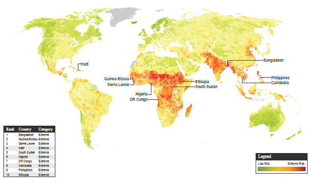
Climate Change Vulnerability Index 2014, maplecroft.com accessed April 2015
While confronting a changing climate, one of the greatest advantages we have with all of our “cheap” carbon energy is the ability to acquire knowledge about the system in which we reside. We are able to imagine, engineer, and create ways to gather and analyse information like never before. Analyzing satellite and in situ measurements of temperature, precipitation, soil type, land cover and land use, is imperative for understanding how our planetary environment is reacting to the increasing atmospheric concentrations of greenhouse gases.
The sheer amount of data we have (and continue to amass) can be quite overwhelming. For NASA missions alone, hundreds of terabytes are gathered every hour, where just one terabyte is equivalent to the information printed on 50,000 trees worth of paper. This flood of information has extraordinary potential in helping to predict and manage our changing world – if we can sift through and make it all accessible and usable. <!–break–>
ESIP Federation is comprised of many different work groups and work clusters, all dealing with Earth science information in various ways, and I have the privilege of being the student fellow for the Agriculture and Climate Cluster. Since January, I have worked with the cluster to discuss and identify data sources and tools that are useful for agricultural adaptation and management for responding to and mitigating climate change. However, in beginning to create this inventory, one major question resonated with the cluster: Hasn’t this been done already? In several different ways by many different groups? What can we (as an ESIP work cluster) do that could uniquely add to what is already out there? How can we create something useful, but not reinvent the wheel?
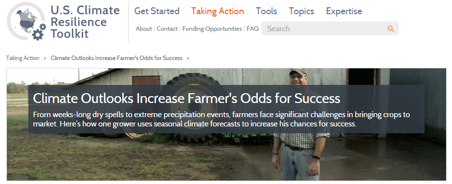
Deciding to pursue discussions with other groups working on similar agricultural data inventories, the Agriculture and Climate Cluster recently spoke with Jim Fox from the Climate Resilience Toolkit (CRT). This toolkit is able to be utilized by farmers, city planners, and any end user to help sift through important datasets that could be useful in making management decisions based on climate data.
The goals set by the CRT team are as follows:
- Help users move from data acquisition to action
- Provide users with tools and information that will help with risk and uncertainty
- Help users to look at situations from a value perspective
- Provide users the decision making building blocks, and relate the data to what people care about
The CRT presents information and data in an easy-to-utilize form by highlighting case studies. Users can search for climate resilience problems that other people are already solving, and can then see the datasets and tools that are being utilized in these particular cases to take action. For example, farmers may be interested in drought risk potential, and they can search the CRT for case studies dealing with drought related problems. They might come across this case study in which a farmer is using precipitation data to help make crop management decisions for drought resilience.
Climate Resilience Toolkit: climate.data.gov accessed April 2015
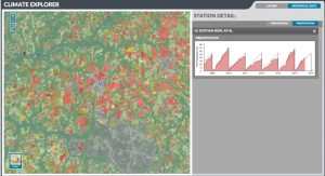
The CRT then makes it easy for the user to be able to apply the same dataset or tool over their location of interest, while also allowing them the freedom to alter the settings to better fit the user’s specific situation and desire.
Climate Resilience Toolkit: climate.data.gov accessed April 2015
The CRT is just one new and dynamic way to think about cataloguing and utilizing Earth science data, but there are many other various portals and interfaces, inventories and data spaces that already exist and are trying to make sense of all the data and to capture an ideal organizational structure to house it. Though not wanting to reinvent the wheel is a reasonable desire, it is important to acknowledge that the wheel really hasn’t been perfected yet.
With a unique position within the larger ESIP Federation (with representation by organizations such as NASA, NOAA, and the USGS along with many different universities, researchers, computer scientists and decision makers) the Agriculture and Climate Cluster is in a unique position. As we move forward in creating a data inventory system, it will be important to continue to look closely at and learn from similar systems already in existence while drawing from the wealth of knowledge and expertise of ESIP members.